Riverside State Park Glen Tana Expansion Opportunity: Long-Term Boundary and Land Classification Update
Project summary
Washington State Parks is conducting a public planning process to update the long-term boundary for Riverside State Park to include the property known as Glen Tana. This project adds over 1,000 acres just outside Spokane, expanding recreation opportunities and environmental protections in a high-demand, urban setting.
- Location: Riverside State Park
- Estimated start date: August 2023
- Estimated end date: August 2024
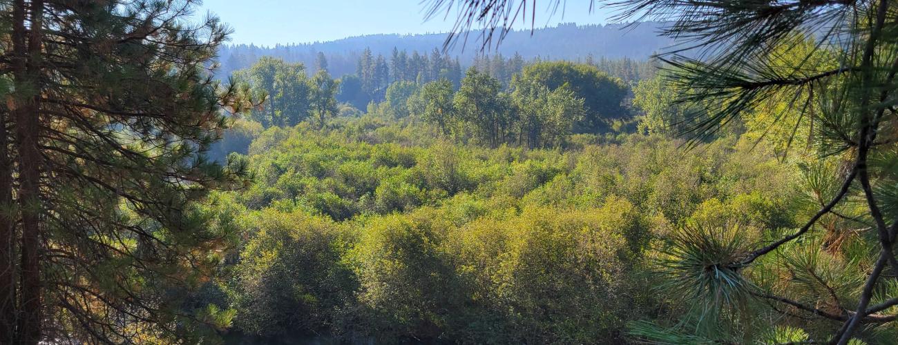
The Glen Tana property, just over 1,000 acres to the northeast of Riverside State Park, includes nearly 2 miles along the Little Spokane River. It provides habitat for many wildlife species and connects existing recreational and conservation areas with Riverside State Park.
Through a unique partnership between Washington State Parks, Inland Northwest Land Conservancy (the Conservancy), and the Spokane Tribe of Indians, Glen Tana presents exciting opportunities for environmental stewardship, expanded recreational access, and supports salmon reintroduction efforts, all within close proximity to the growing metro-Spokane area.
The long-term boundary adjustment and land classification update are a central part of Parks' park planning process, known as CAMP. Land classifications range from low to high-intensity land uses. By classifying park lands, Parks strikes a balance between protecting park resources and providing an appropriate variety of recreational opportunities for park visitors.
Considering changes to the long-term boundary allows the agency to take a big picture look at what lands might advance the conservation and recreation mission of a park. Incorporating Glen Tana into Riverside’s long-term boundary allows Parks to acquire and plan for the future use and management of the property.
For more information on the historical context of the Glen Tana property's importance to the Spokane Tribe of Indians, visit History – Spokane Tribe of Indians.
A brief video, from Inland Northwest Land Conservancy, on the Glen Tana story and the Conservancy’s commitment to acquiring and preserving this property for future generations can be viewed on YouTube.
For more information, visit the Inland Northwest Land Conservancy website: Glen Tana: Future for Salmon and Trails in Spokane.
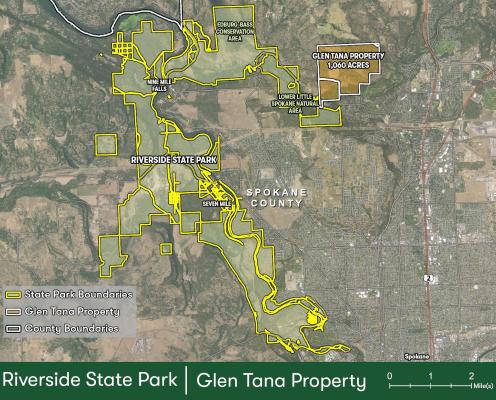
The following image is an aerial view of Riverside State Park's boundary, which is highlighted in yellow over a satellite image of the park and surrounding region. The Glen Tana Property,1,060 additional acres located at the northeast edge of the park, is highlighted in orange.
Community participation
We Want to Hear from You
State Parks balances providing recreational opportunities with environmental protection. We'd like your help finding the right balance for Glen Tana: take the Stage 2 Survey and tell us what you think.
Provide written comments, questions, and suggestions by completing this comment form.
Events:
Stage Two Public Workshop
The Stage Two Public Workshop to explore alternatives based on input from Stage One Public Workshops took place: April 18, 2024, from 5:30 - 7:30pm, at Saint George's School, 2929 West Waikiki Road, Spokane, WA 99208
For those who could not attend in person, a recording of the Stage Two Public Workshop will be available here.
Project history
CAMP is a multi-staged, public participation-based planning process for individual parks that culminates with adoption of park land classifications, a long-term park boundary, and a park management plan.
Stage One: Identify Issues and Opportunities
Stage One occurred in the fall of 2023. During this stage of the CAMP planning process, we seek to learn what is important to the park community. Stage One is an opportunity to hear hopes and concerns as a big-picture exercise to set the course for the next stages of the planning process.
The Stage One Public Workshop can be viewed here: https://www.youtube.com/watch?v=iXeLxYXcUx0&feature=youtu.be
Documents
Public Comment
Stage Two: Explore Alternative Approaches
Using input gathered in Stage One, alternatives are presented in a second public workshop. The alternatives offer solutions and strategies to address the hopes and concerns raised during the initial planning stage.
Stage Three: Preliminary Recommendations
In this stage, the most suitable ideas from Stage Two are combined into a preliminary plan. The plan may include recommendations for land classifications (uses), changes to the park’s long-term boundary, and solutions for concerns raised during the planning process.
During this stage, the State Environmental Policy Act (SEPA) checklist that describes environmental impacts associated with the recommendations is completed.
The Stage Three Public Workshop is scheduled for late spring 2024.
Stage Four: Final Recommendations
At this point in the planning process, final adjustments to the proposed recommendations are made and submitted to the Washington State Parks and Recreation Commission for approval. The public is encouraged to attend the Commission Meeting to provide in-person, virtual, or written comment.
The Stage 4 Public Workshop is scheduled for late summer 2024.